
HISTORICAL HARDSHIP: August 23-24 storm swells Upper Iowa River to record levels, results in flash flooding and other damage
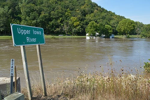
Storms that made their way through northeast Iowa overnight Tuesday, August 23 into Wednesday, August 24 resulted in a new record crest of 24.3 feet for the Upper Iowa River recorded by the National Weather Service around 9 p.m. Wednesday, August 24 at its Dorchester measuring station located at the Upper Iowa River Bridge along State Highway 76. That new record level forced closure of the bridge until early Thursday morning, August 25, when the above photo was taken and the waters had receded back near the previous record level of about 22.5 feet. The National Weather Service reported approximately 5.5" of rain fell in the Dorchester area with the storm, but the more than 8" of rain that also flooded the Decorah area with that same storm made its way downstream to compound the river's flow and leave a path of flooded homes, farmland and washed out river banks and roadways in its wake. The storm also caused flash flooding that closed additional roadways throughout the county and caught many area homeowners and visitors off guard. Standard photo by Joe Moses. Additional photos from throughout the county can be found in the print version of The Standard and at the Photo Gallery link on this website.
It was less than a 12-hour period of rain, but it left an impact lasting days, weeks and even months, and an end result of historical proportions that will be remembered for a lifetime by many.
The overnight period of late Tuesday evening, August 23 through early Wednesday morning, August 24 saw heavy rainfall move in quickly and hover over northeast Iowa, dumping rainfall totals of anywhere from 3.5” to 8.5” that raised river levels, washed out roadways, flooded properties and left an incredible amount of clean-up in its wake. In addition to the property damage impact felt throughout Allamakee County and four neighboring counties that initially received a disaster declaration by Iowa Governor Terry Branstad due to the storms, it was Chickasaw County in northeast Iowa where the ultimate loss was suffered, as a 77-year-old man from Sumner lost his life near Lawler when he was swept away by flood waters after fast-rising water stalled his vehicle.
Local property damage ranged from water in local basements due to saturated ground, to flood waters rushing through homes, farm buildings and cropland from adjacent water bodies. The most significant of that damage suffered in Allamakee County occurred along the Upper Iowa River valley, where the National Weather Service reports rainfall totals of 5.5” to 6” fell in the Dorchester and surrounding area.
In addition to that local amount, rainfall totals of eight or more inches that fell in the Decorah area of Winneshiek County with that same storm flooded that area, with those swollen waters then making their way down the Upper Iowa River to compound the rising water trouble downstream. That troublesome combination resulted in flooding of historic proportions on the Upper Iowa River near Dorchester, where the river finally crested at a new record high level of 24.3 feet, nearly two feet higher than the previous flood record of 22.5 feet set June 9, 2008.
"This flooding took everyone by surprise," noted Allamakee County Sheriff Clark Mellick in regard to how swiftly and how high the waters rose. "Usually, we have a 15-16 hour notice when there is flooding in Winneshiek County."
Within a couple hours of the rain beginning to fall in the Allamakee County area at around 9 p.m. Tuesday evening, the Upper Iowa rose to above its 14-feet flood stage on its way to just over 19 feet by 9 a.m. Wednesday morning, August 24, where it plateaued for just a bit before feeling the surge of the flow from upriver in Winneshiek County. While very little, if any, rain fell throughout the day Wednesday, the Upper Iowa continued to rise, finally cresting around 9 p.m. Wednesday evening at its new record level, reaching new heights of destruction and recovery clean-up as well.
In addition to the immediate challenges of safety and rescue efforts, Sheriff Mellick said one of the greatest challenges of an event such as this is "determining who needs what" throughout the recovery process. "If people need assistance, they can call our office. We are there to help or refer them to the correct agency, such as the Red Cross," he advised.
The slow fall of the Upper Iowa began overnight Wednesday night, finally falling below its 14-feet flood stage Friday evening, nearly 48 hours after cresting, and continuing its downward trend toward its traditional flow level under nine feet, where it was anticipated to finally reach nearly one full week after its historic crest.
The flooding of that Upper Iowa River forced closure of State Highway 76 at the Upper Iowa Bridge overnight Wednesday. In addition to closure of that State Highway, the list of closed roads throughout Allamakee County reached approximately two dozen Wednesday throughout the county and, much like the floodwaters, decreased throughout the remainder of the week to just around a half dozen by the weekend - some of those due to needing flood damage repair rather than overflowing water and many of those same half dozen remaining closed yet this week.
Those road closures delayed school in the Eastern Allamakee Community School District and resulted in school buses not traveling in northern Allamakee County Wednesday, August 23 for the Allamakee Community School District. County Road A26 (Iowa River Drive), running adjacent to the Upper Iowa River, was the final paved road to re-open, doing so by early Friday morning.
Allamakee County Engineer Brian Ridenour advised that some roads throughout the county are still closed, and he cautions everyone to continue to drive with caution and obey signs that indicate a closed road. "Don't drive through water because the road may not even be there," he warned. "Many roads are still very soft, including shoulders, and some are narrower because of the flooding."
Ridenour said his department's initial priority is restoring access for everyone to their property in a flood situation. "Isolated people are difficult to reach with emergency services, so we try and restore that access as quickly and safely as we can," he advised.
He further explained that main pavements are also a higher priority, including repairing road shoulders. He also said that there are a number of culverts that are likely plugged with flood debris that need to be cleaned out and possibly repaired, making an already long recovery process from the flooding even longer. "Our crew is doing well," Ridenour offered. "The Sheriff and Emergency Management Coordinator have been great to work with through all of this."
CAMPGROUND CHAOS
Among the most impacted areas by the swiftly-rising waters were area campgrounds, none more than Upper Iowa Resort and Rental staged along that swelling Upper Iowa. Reports of nearly two dozen campers and trailers being displaced by the force of the rising waters emerged from the campground, where the main office and camping area were flooded and the home adjacent to the campground owned by Brian Dougherty visible from State Highway 76 also experienced rising water up near its first floor windows.
Although Red Barn Resort and Campground in Lansing did not experience the camper and overall flooding loss of a swelling river, one of the most dramatic rescues of the storm event did take place along Clear Creek that runs through the campground. A flash flood that forced the creek to rush out of its banks caught an older Cedar Rapids couple enjoying a cabin stay off guard as the rushing waters picked the cabin up off its foundation in the very early morning hours of Wednesday, August 23 and began carrying it downstream with the couple inside. The Lansing Fire Department was dispatched to the scene, where crew members were able to get a boat through the flooded creek and then pull the boat with the couple inside back to solid ground. Reports indicate that had it not been for the cabin getting caught up in a small grove of trees, there may be no telling where it would have ended up or how differently the incident may have ended.
Campgrounds in Yellow River State Forest were also closed throughout the past weekend for clean-up efforts resulting from fast-rising streams. Additional flash flooding and surging water throughout the county left an abundance of debris clean-up, mud and rock slides, road and street damage, and flooded cropland throughout the county as well.
Allamakee County Emergency Management Coordinator Corey Snitker says the fact that he has only been in his new position for four months made this first disaster a "learning experience" for him with each differing situation. However, the basic strategies of his position in any emergency situation of this nature remain much the same. "In the short-term, safety of the public is of highest priority; contacting homes that are historically isolated when flooding occurs and opening roads to these locations as quickly as possible," Snitker explained. "We also want to determine the immediate needs of the public concerning shelter, food and water."
Much like meeting the immediate needs in such a flooding situation, Snitker says that long-term strategies are also multi-faceted and involve many different County departments. "Debris removal from homes, businesses, farms and roads, and repair of roads that were flood damaged," Snitker said of the more typical long-term needs of flood recovery. "I also want to provide information to the public about any financial support that might become available and any services that are available also."
WITHIN WAUKON
As was the case throughout the county, the community of Waukon was also filled with basements leaking water, including downtown businesses. Although rainfall totals and frequency were compared to previous flood years of 2008 and 2013, the one significant physical difference within the community with this storm is the new detention basin constructed in the northwest corner of Waukon this summer for the purpose of controlling the results of the kind of rainfall that fell in the Waukon area (reported to be seven inches by the National Weather Service). The basin was reported to be at or very near capacity with the Tuesday/Wednesday storm, leaving local residents to wonder what the results of this storm may have been like had the basin not been constructed.
Official reports of recovery and clean-up assistance by local, regional and state officials can also be found in this week’s edition of The Standard on Pages 1A and 2A.
Sheriff Mellick further advised that even though the most immediate threat of flooding waters may have subsided a bit in the week's time since the storm, caution still needs to be taken. "The ground is saturated, road shoulders may have washed away or can be soft," he said. "Trees can still tip over, so be careful when driving. The rivers are high and too dangerous for boating or kayaking. Debris on the river is a hazard."