
Earliest known plat map of Lansing donated to Meehan Memorial Lansing Public Library
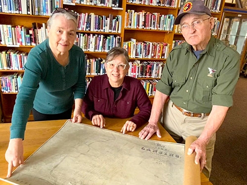
Map of Lansing from 1854 donated to library collection ... Left to right in the above photo, Meehan Memorial Lansing Public Library Director Derva Burke, Lansing resident Ellen Modersohn and Lansing history buff Bill Burke display an 1854 lithographic print map of Lansing that will join the library’s local history collection. Burke knew of the map through some of his other historical research and Modersohn had discovered it available for sale online, also during her research of Lansing history. Bill Burke then purchased the map and recently donated it to the library. Photo by Bob Modersohn.
An 1854 plat map of Lansing, which played a pivotal role in the early development of the city, has been donated to the Meehan Memorial Lansing Public Library by Lansing resident Bill Burke.
While Ellen Modersohn, also of Lansing, was talking with Burke one day last fall he mentioned that he knew of the map’s existence but did not know where it was. Modersohn later realized she had found the map listed for sale online while researching Lansing history. The tab for the site with the map was still open on her computer, so she passed the information along to Bill and Derva Burke.
“My interest in the map was spurred when I came across the will of Charles Clifton Aird when looking for another document in the Allamakee County Recorder’s Office several years ago,” Burke said.
According to Burke, in his will, Aird bequeathed three items to the city of Lansing, including the 1854 map, which would have been the first map of the city. Although the map was willed to the Lansing library, there is no evidence that the library ever received it, nor did the library receive a map of the county also willed to it by Aird.
The 1854 map is important because it was drawn at least two years before the city was officially platted. The plat was recorded at the Allamakee County Courthouse March 10, 1856, by Horace Houghton and John Haney. The 1854 map is almost identical to the actual plat map of 1856. It was earlier assumed that the first map of Lansing would have been the official plat map, but it wasn’t.
To read the full article, pick up the Wednesday, March 13, 2024 print edition or subscribe to our e-edition by clicking here.