

Wednesday storm determined to not have rotation but still does significant damage in southern Allamakee County

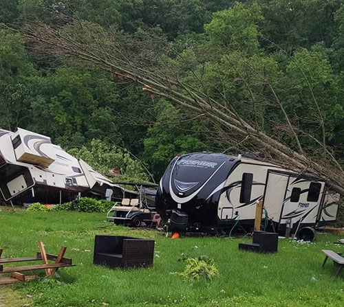
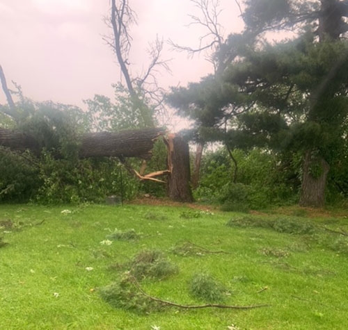
Storm damage most evident in southern third of county ... The three surrounding photos submitted by Allamakee County residents and visitors show the power - both during and afterward - of the worst of the severe storm that roared through the southern one-third of Allamakee County Wednesday afternoon, June 12. Misty Troester of Harpers Ferry caught what has been termed the “gust front” of the storm in the top photo. Cedar Falls resident Kaylee Smock submitted the photo at center showing damage done by the storm to campers - including her family’s - at Scenic View Campground. The photo directly below shows some of the tree damage suffered to 15-20 trees at the rural Postville residence of Nick and Mandy Dudensing east of Frankville.
The severe thunderstorm that rolled through Allamakee County Wednesday afternoon, June 12 left a path of destruction with its high winds, the worst impact of which was felt throughout the southern one-third of the county, just north of Postville and just south of State Highway 76, according to reports. A vast majority of those reports indicate the damage suffered was mainly to trees and, as a result, some power lines that fell victim to those trees, in what local officials describe as a “unique event.”
That uniqueness stems not necessarily from the storm itself and the high winds, frequent lightning and heavy rains that typically accompany such a storm, but from its precursor that inflicted much of the damage with the highest winds and what many described as a “funnel cloud” in weather spotter and other communication between area authorities, in addition to local residents who witnessed the event - and even captured images of it, as evident in one of the photos accompanying this article submitted by Misty Troester of the Harpers Ferry area.
However, National Weather Service officials tracking the storm instead labeled the seemingly ground to sky mass that traveled across the southern portion of Allamakee County a “gust front”. The National Weather Service defines a “gust front” as “The leading edge of gusty surface winds from thunderstorm downdrafts; sometimes associated with a shelf cloud or roll cloud. See also gustnado or outflow boundary.”
NO ROTATION, ABUNDANT WARNING
Despite its appearance and descriptions shared by area weather spotters that were relayed by Allamakee County Emergency Management Coordinator Corey Snitker to the National Weather Service (NWS) in La Crosse, WI, NWS officials shared with Snitker that there was no indication on radar of any rotation and, thus, no confirmation of any funnel cloud or tornado activity. Thus, there was no issuance of a Tornado Warning, although several communities within the storm’s path - including Waukon and Postville - did sound their outdoor warning sirens to make people aware of the approaching severe weather.
“We would always rather be safe than sorry in instances like this,” Emergency Management Coordinator Snitker said in regard to the sounding of the outdoor warning sirens. Snitker also said there will be no post-storm surveys conducted by the National Weather Service.
National Weather Service officials offered the following observation when Troester’s photos were shared with them by Snitker: “This blowing dust/dirt all looks consistent with the gust front and storm outflow pushing through just ahead of the storms. There’s no evidence of the dust cloud being connected to the cloud base aloft to suggest a possible circulation/tornado. And there isn’t any funnel cloud. It seems this blowing dust/dirt was a common feature all the way from Howard County through Winneshiek and into Allamakee County as the gust front outpaced the storms from the photos, reports, and radar imagery we saw.”
The National Weather Service did issue a series of Severe Thunderstorm Warnings that stretched from Howard County eastward into Winneshiek County and eventually the southern portion of Allamakee County. The first of those warnings in Allamakee County was issued just before 3 p.m. that Wednesday afternoon for the southwest quarter of the county, along with the southeast corner of Winneshiek County. Just over a half-hour later - shortly after 3:30 p.m., a second Severe Thunderstorm Warning was issued for the southeast quarter of Allamakee County, along with most of Clayton County and extending across the Mississippi River into Wisconsin.
To read the full article, pick up the Wednesday, June 19, 2024 print edition of The Standard or subscribe to our e-edition or print edition by clicking here.
